The short-sighted exploitation of a desert

The Owens valley roughly runs from North of Bishop to South of Lone Pine just west of the California – Nevada Border. To the West the Sierra Nevada rises to a height of above 4000 m, with Mount Whitney at 4421 m the highest peak in the contiguous 48 states. To the east the mountain ranges are lower, but Telescope Peak, the summit of the White mountains, reaches 3368 m and Waucoba mountain in the Inyo mountains 3390 m. The valley floor is at 1200 and 1800 m. This makes Owens valley one of the deepest valleys on the American continent. The maximum depth of the Grand Canyon is 1829 m.

Mt. Whitney above Lone Pine
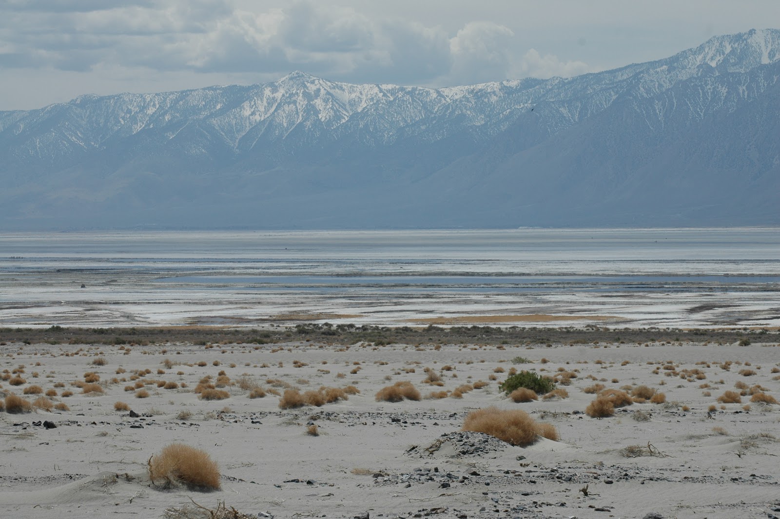
The valley has a climate of eternal spring and blue skies. Due to the Sierra Nevada to the west the valley receives very little rainfall . Therefore the sky is eternal blue. The valley is home to Owens river, 290 km long. The river originates 6 miles north of the city of Mammoth Lakes close to Yosemite national park and ends at Owens Lake south of the town of Lone Pine. The river collects all the water running off the eastern slope of the high mountains of the Sierra Nevada. Owens lake has no outlet and a high evaporation. Its high salinity makes its water useless but supported rich wildlife and an enormous population of birds.

The historic Dow Villa Hotel
We stay in a pleasant hotel in Lone Pine. The origins go back to 1923 when the main building was built. The motel part with pool and jacuzzi was added later. Of course both are full of water even now, in the middle of winter, with freezing temperatures at night. The old building even has a nice library and sitting area with an open fire place. The premises also house a pleasant restaurant. In the bathroom, at the side of the toilet, is a curious little knob. When I bend down to turn it I get a face wash. It operates a jet spouting upward to where my face happens to be.
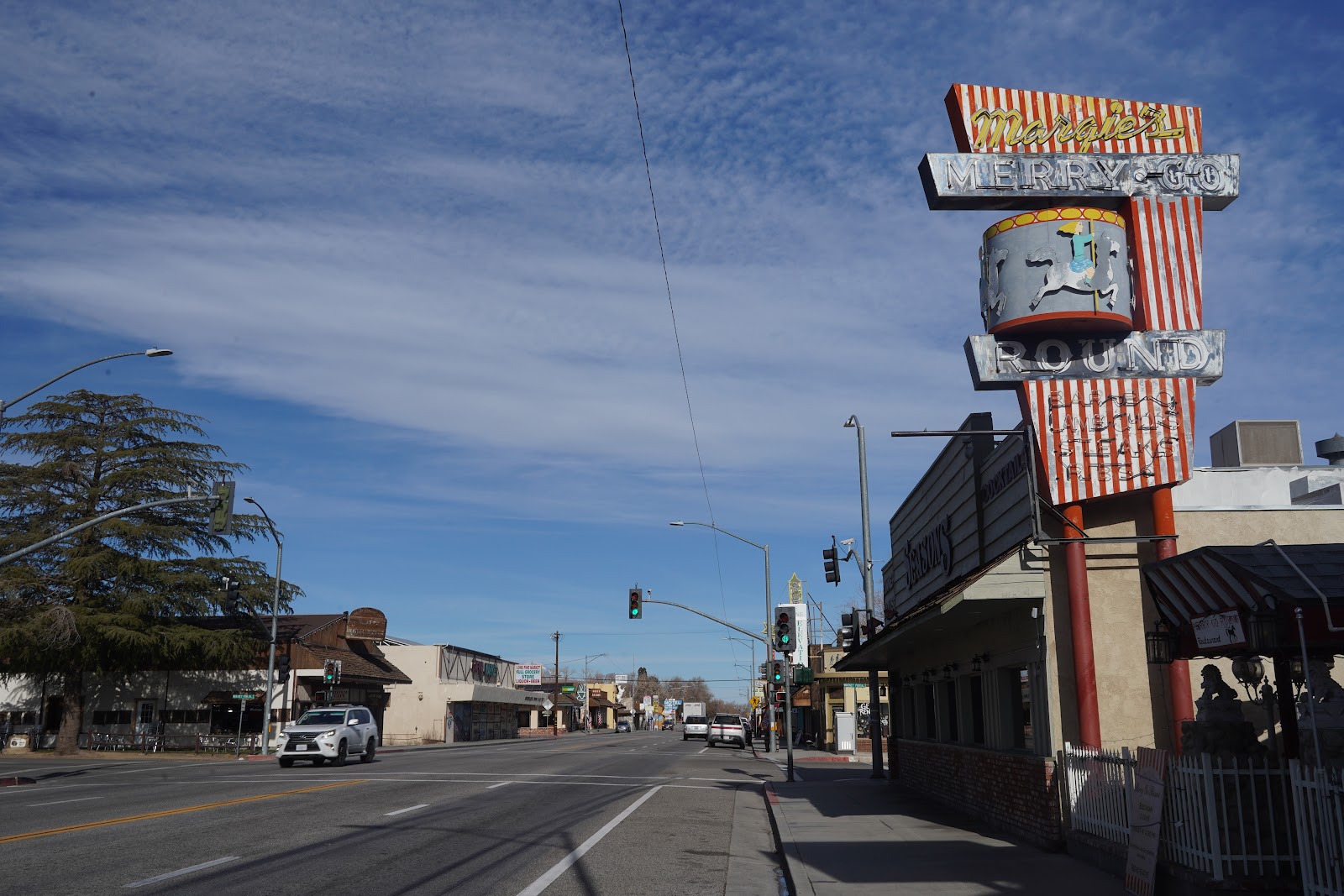
US 395 in Lone Pine
The main street of Lone Pine, US 395, is a busy thoroughfare where drivers immediately step on the brake when you put your foot on the pavement. For good measure, and it is the first time I ever saw this, they have dispensers with flags attached to sticks which you can carry with you to draw attention while crossing. Main street is lined with buildings reflecting the air of a frontier town. Most house souvenir and outdoor shops. However, there also is a supermarket.

The pioneer cemetery
When I get up and go for a morning walk the air is crisp and the sky blue. The range of the Sierra Nevada seems to hover right above me. The high mountains including Mount Whitney are covered in snow. The tracks of spur roads can be seen crisscrossing up the steep slopes of the foot hills. Although there are some residential streets parallel to main street I am in the middle of the countryside after a short walk. A horse snuffs curiously. Roosters crow. The dry grass and remaining leaves in the trees rustle in the subtle breeze.

Center of Lone Pine
We find a pleasant cafe for breakfast and immediately get involved in a little chat with a couple of other old-timers in the booth next to us. Topic is the burden of age. The walls are decorated with pictures of movie stars. When I forget my backpack including a 2000 $ camera in the cafe after breakfast it still is in the booth untouched when I come back to retrieve it half an hour later.
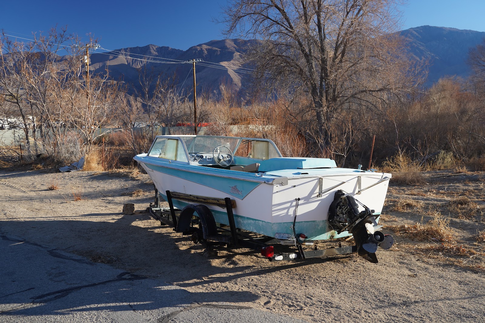
Dilapidated boat in Lone Pine
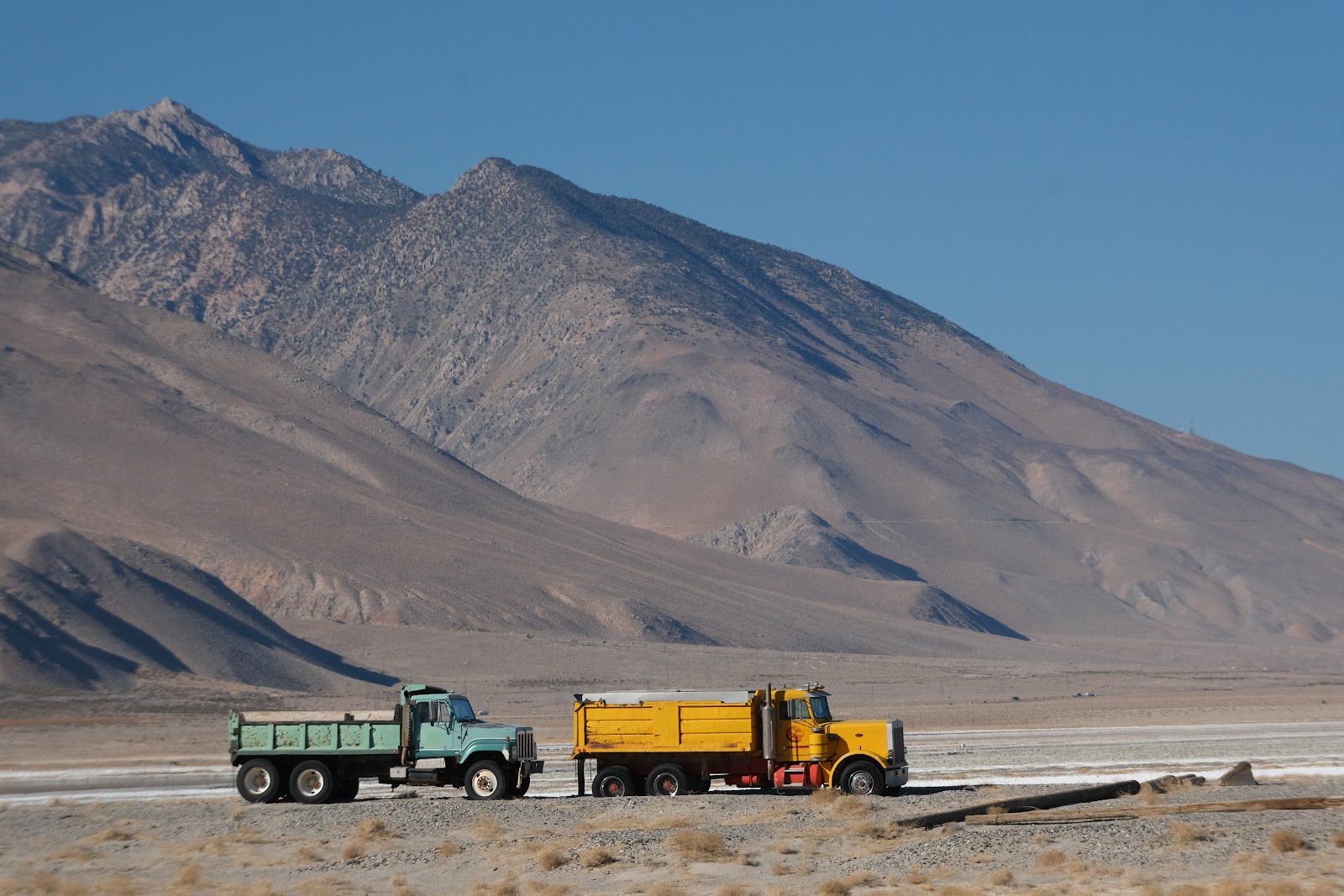
The yards of the town preserve their share of junk and car wrecks. There are a number of dilapidated boats in the middle of what seems to be a water-deficient savanna landscape. Enormous pick-up trucks with huge tires appears to be the most popular means of transport.

Moebius Arch, Alabama Hills
Although the Sierra Nevada seems so close it is miles away and separated from the valley floor by the Alabama hills. It is an area of granite boulders with lots of short trails adequate for the elderly. There is the usual assembly of formations with fancy names like Mobius arch, Eye of the Alabama and the corridors. The presence of the Alabama hills and their backdrop, the Sierra Nevada, is the main reason that this area was so popular with the Hollywood movie industry. More than 400 movies have been shot here. Lone pine houses the museum of Western Film History. They know all about it. The town also houses a film festival every October.

The corridors
Many of the actors like William Boyd, Roy Rogers, Gene Autry, John Wayne, Pat Buttrum, Stewart Granger, Errol Flynn, Robert Mitchum, and Clayton Moore have stayed in our hotel. I guess they don’t film a movie here at the moment since we still can afford our rooms. Today virtual reality offers even more scenic locations for the spectator. But maybe the area also lost popularity as film location since the times when Western movies were popular are gone. Although they have filmed movies from other genres like Science fiction here as well. Examples were Star Trek generations or Tremors. Best known recent film is Django unchained. I am pretty sure that John Wayne has enjoyed the face wash in my bathroom as well.

Eye of the Alabama
Camp site use is strictly regulated in the Alabama hills. Little signs clearly indicate when spots are for day use only. Most are. My friend W. is disgusted. That has not been so before. It is doubtful whether people actually care what the signs say. We make a comment to two guys who are about to set up their camp around two enormous pick up trucks. They shrug their shoulders. Just a bit further up, at the northern end of the Alabama hills, one of the day use spots offers a seemingly endless view of Owens valley disappearing between the towering mountains on both sides. Vegetation is mainly waist high scrub, if there is vegetation at all.

Owens valley north of the Alabama hills
Traditionally there were no trees in the valley due to the lack of rain. However, the area had a small population of Paiute Indians who used the water of the river for some irrigation farming. After the first settlers had arrived and done away with the Indians in the 1860’ies they took over irrigation farming from them. At the begin of the 20th century 16000 ha were under cultivation in the valley. The agricultural production was mainly sold to the booming mining towns in the area. In particular Rhyolite in Nevada and Bodie in California attracted fortune seekers. In addition, the miners occupied in Death Valley to the east had to be supplied.
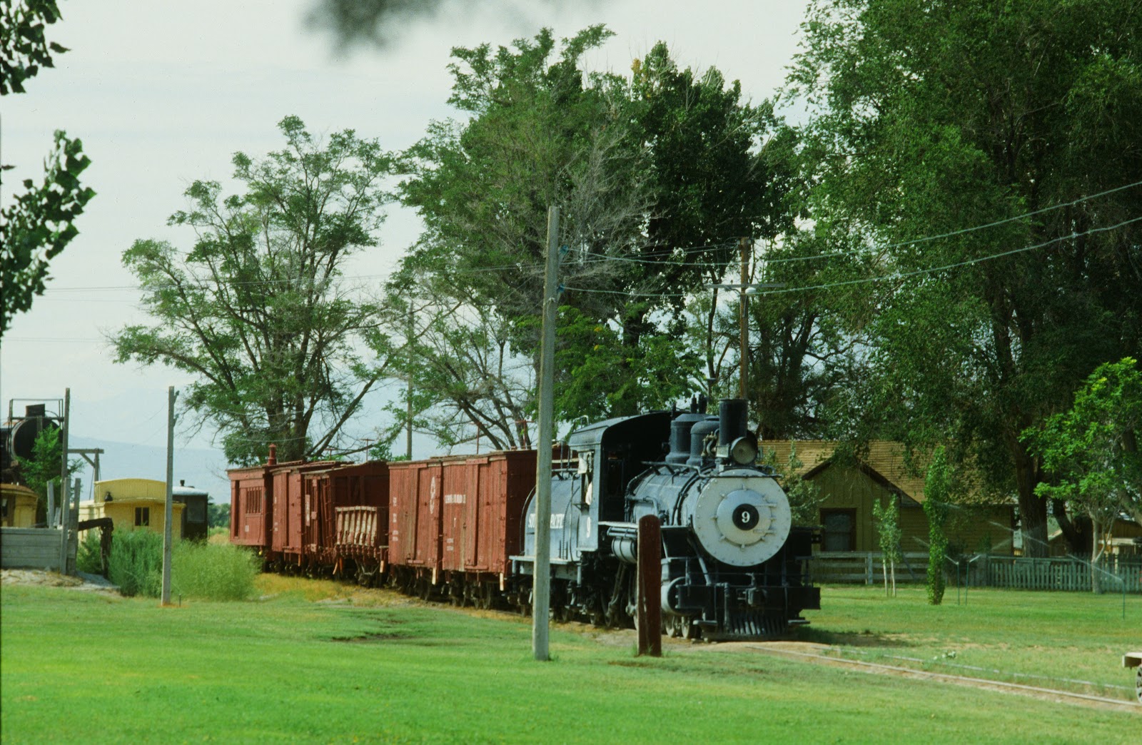
Slim princess # 9 in the museum in Laws 1988
To provide transportation for residents and products between the valley, the mines and the outside world a narrow gauge railroad already was built in 1883. The Carson & Colorado connected Keeler at Owens lake with the Nevada and the Virginia and Truckee railroad and Belleville. The old station in Lone Pine, now a private residence, still exists.

Former railway depot of Lone Pine
The engine was nicknamed “the slim princess”. The line was long, there were many princesses. Two are preserved. One in the Eastern California Museum in Independence and the other in the former depot of Laws, outside Bishop. The Laws railroad museum and historical village not only preserves a slim princess, # 9, but also cars, depot buildings, the water tower and a turntable for the engines. They have added a lot since the photos were taken in 1989.

Former engine turntable in Laws
Southern Pacific operated the narrow gauge line to Keeler until 1960. Originally Keeler at the shore of the saline Owens Lake was at the waters edge. The lake was so big and had such a lot of water that a steamer provided transport for a while. Above Keller, in the mountains is Cerro Gordo, a peak of 2800 m.

Owens Lake
Silver was discovered around Cerro Gordo in 1865. By 1869 the remote town was the largest producer of silver in United States. It was connected to Owens lake by an aerial tramway about 13 km long At the town’s height there were a couple of hundred buildings.

Road to Cerro Gordo, in the valley Owens Lake
We see a sign at highway 136 pointing at a dirt road up the hill. Cerro Gordo. My friend W. thinks it indicates a concrete structure visible from the road. Later it turns out that it was a smelter treating the ore from the mines. Cerro Gordo is more than 1500 m up a steep and winding dirt road. Although the road supposedly is suitable for 2 WD W. has to push his 4x4 hard to get up the hill. The clutch starts to stink. Maybe the car just is too heavy for steep roads? Later, on the way down, which we have to do in a kind of hurry because it is beginning to get dark, it is the brakes which begin to stink.

Spiny world
The scenic road offers a beautiful view of Owens Lake with the snow covered crest of the Sierra Nevada as backdrop. Everything is spiny here. In the foreground Joshua trees stand like statues of a spiny ghost. The meadows are covered with barren, leaf-less, spiny scrubs. The slopes are covered with sharp-edged rocks.

Mine hopper
The area is dotted with mine shafts. On route we pass the hopper of a mine. Cables hang useless in the air. The shaft is given away by a pile of tailings a bit further up the slope. Another dirt road branches off towards the hills.

View from Cerro Gordo to Owens Lake
The mining industry was very short-lived. Many of the mines were closed after a few years. Most of the fortune seekers moved elsewhere without finding wealth. They were only interested in quick profit, had neither interest nor money nor sufficient knowledge for long-time investment.

The museum of Cerro Gordo
After mining stopped at Cerro Gordo for good in 1957 a caretaker was left to watch the slow decay of the buildings. Left over are the remainders of half a dozen buildings, a church, but also a number of structures looking quite new. One of the buildings is used as a museum. An enthusiastic volunteer sitting in the sun on the platform at its entrance gives us an introduction. The entire ghost town was bought in 2018 by Brent Underwood and some investors for 1.4 million. Unfortunately three of the structures soon burnt down. One of the restored buildings is used as a residence by the owner when he is here. Another serves the volunteers who work for the restoration, give guided tours and run the gift shop. The biggest building is going to be restored to be a hotel. Our guide shows us photos how they dragged an enormous septic tank up the hill. The owners have started a Youtube channel to broadcast the progress of the project.
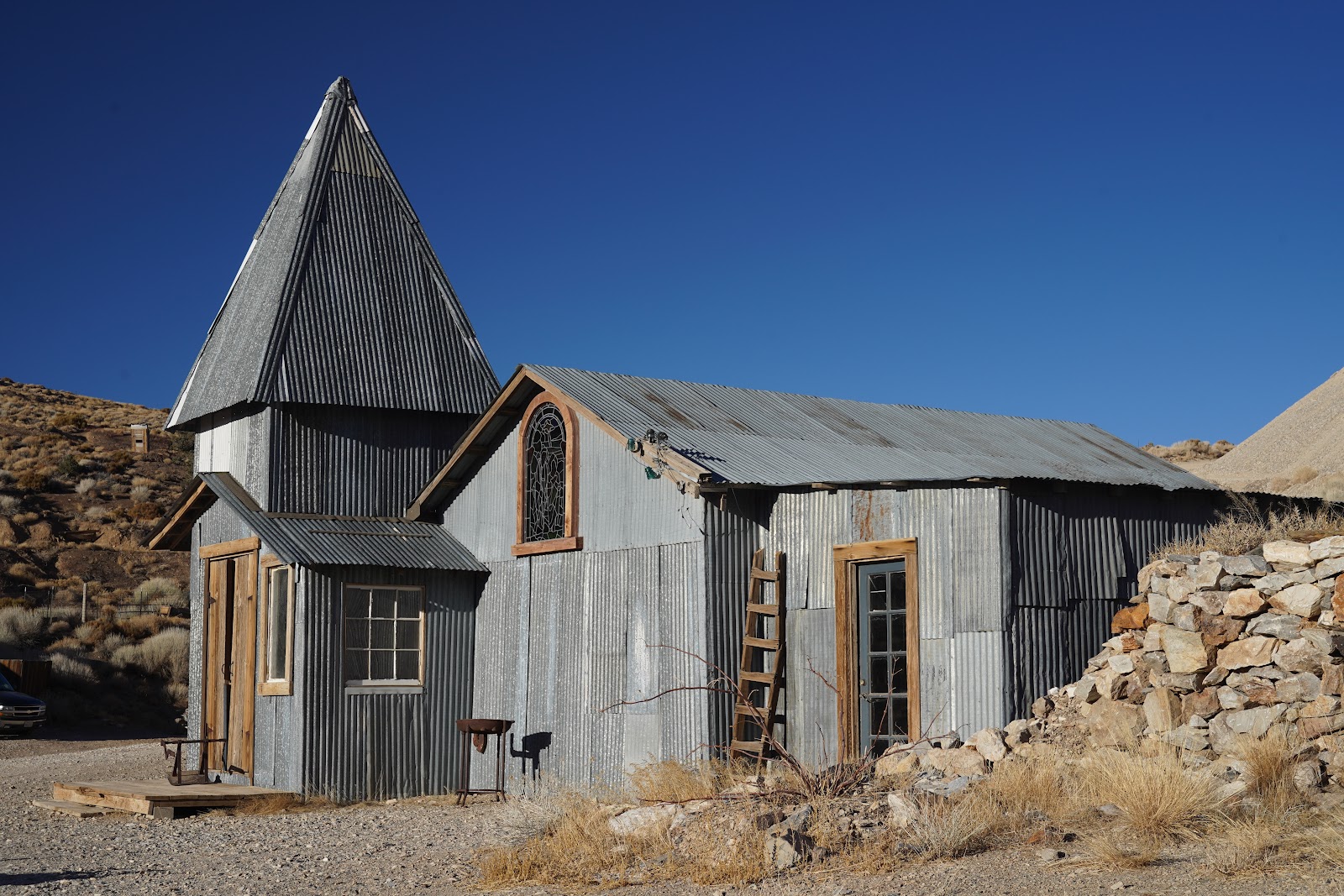
The church of Cerro Gordo
After the introduction we are free to walk around. We are warned to not come close or enter any mine shafts. The area is dotted with discarded mining equipment, car wrecks and wooden beams and planks. The former church is used as a movie theater. The colored glass of the windows gives the room an eerie sphere.

The brothel of Cerro Gordo
They tell us that the building above the church was the brothel. It is interesting that it remained as one of the last of originally hundred buildings. There are small chambers each with the frame of a bed. The springs point towards the ceiling, the mattress has disappeared.

Panamint mountains
The weather report has announced a snow storm for the next days. We continue to death valley the next day. Even there it starts to drizzle. The volunteer of Cerro Gordo told us that after such snow storms they had been isolated for up to 2 weeks until the road up the mountain became passable again. In today’s fast pacing world, where everything is planned to the minute, none of the hotel guests would appreciate such a delay.
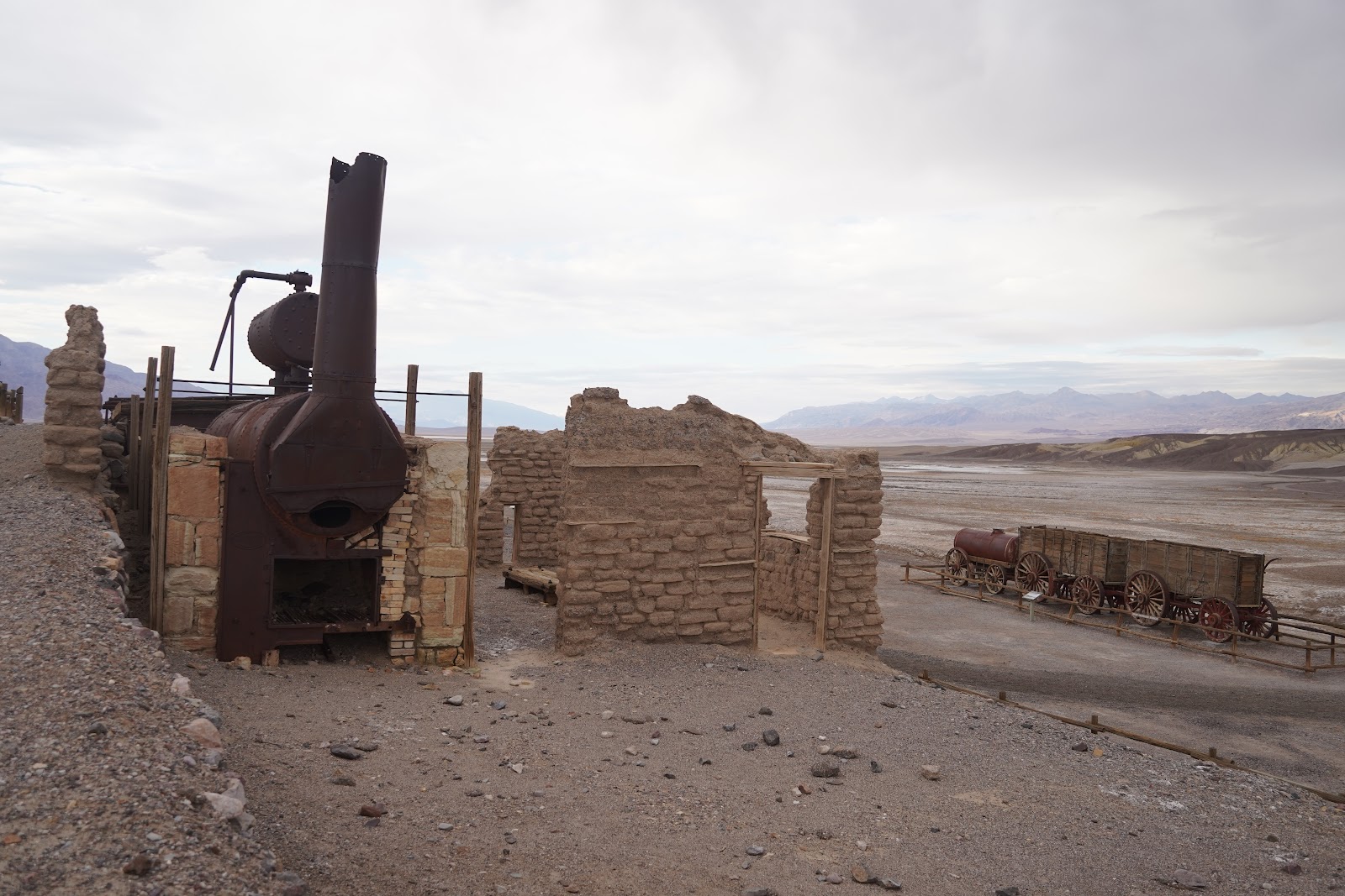
Harmony Borax works
After the annexation of California and the dying out of the gold rush, Death valley soon became a mining hot spot. Mining of borax started in 1883. The white gold can help to lower the melting point of minerals used for glass production, but also in cleaners, disinfectants or pest control agents. or of ore for the production of metals. The mineral was refined at the site close to Furnace creek. The name already tells how demanding the conditions were.

The waggon of a 20 mule train
Since there was no railway access the product had to be brought out to the closest rail head by 20 mule teams. In fact it were big wagons pulled by 18 mules and 2 horses. The horses were leading the mules that tended to be stubborn but willingly followed the guiding horses. Two wagons carrying the sacks with Borax were accompanied by one wagon carrying water for the animals. On the return route the wagons had to carry provisions and fire wood for keeping the furnaces for the fractionated crystallization process burning. But bringing stuff in downhill was easier.

20 mule team canyon to leave Death Valley
Harmony Borax Works only operated for 5 years. The mining of Borax continued at other, easier locations. It is surprising how much of the installation still exists after all the time. What 125 years of climate and looters were not able to destroy is now sacrificed to the crowds of tourists. Railings are set up to prevent people and their children from climbing on the exhibits.

Keane wonder mine
Other mines were developed to extract gold and silver but soon also less precious copper and lead bearing ore or talc minerals. Keane wonder mine was in full operation by 1907. Buckets of ore were hauled down from the shafts by a mile long aerial tramway. While at the height of operations 70 tons of ore were extracted and ferried down for processing daily. By 1912 the mine already ceased to be profitable and was closed by 1942. The towers of the tramway, the wooden ore bunkers, remainders of the stamping mill, an ice house, an outhouse and tanks used for holding cyanide solution for extraction are still visible.

Outhouse of Keane wonder mine
Unlike Keane wonder mine most of the other mines in Death valley were never profitable. There was the Ashford Mill, the West Burro Mine and many others. Few have as many preserved artifacts as the Keane wonder mine.

Ashford mill, 1988
The conditions for the workers were murderous. They lived in tents or crude shelters. Even in winter it can be hot, in summer the valley is like an oven. Then the little spring water there is disappears. There is no shade. Even at night there is no relief from the heat. Many of the workers were Chinese who were treated like slaves.
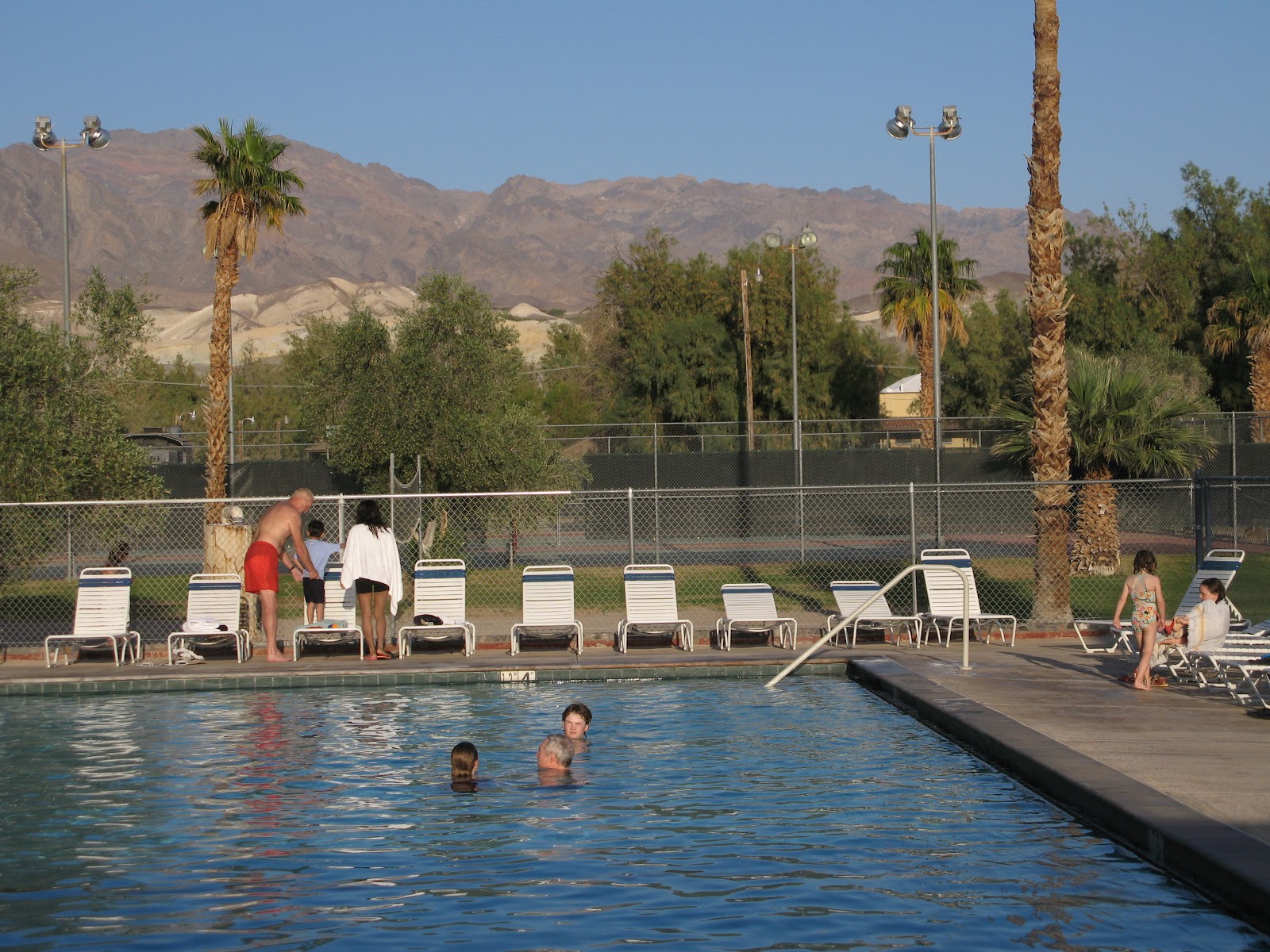
The pool of the Furnace creek resort
Only the managers and privileged workers stayed in solid buildings for example in Furnace creek. Today there are resorts for tourists who expect their share of luxury. Many disregard the harsh desert conditions which can lead to dangerous situations even in winter for example when unsuitable cars are driven on rough roads and get stuck or break down. Telephone reception is not available everywhere.

Inn at Death Valley
We turn up without reservation at the reception desk of the resort at Stovepipe wells. Plenty of rooms are available. For a rate of 200 $ per night the furnishing is basic and a bit worn-out. There is a desk and a chair and of course the ubiquitous television. However, there is a decent restaurant and the Badwater Saloon. We sit at the bar and consume a couple of beer which are not more expensive than elsewhere. To the right a Dutch couple who down two bottles of red wine while we consume two beer. To the left a French lady who is extending her business trip to Las Vegas by a little tour to Death valley. Her English is unfrench, perfect. It turns out that she was born in the US and her children grew up here.

When we go back to our rooms the baby in the room between ours gets active. The walls are thin. When I try to get some sleep with earplugs I discover that the parents are even louder than the baby. I get the impression that this young family and their little critter are the last to go to sleep in this compound and the first, at 6 am, to get up. That will be a long day. The baby will determine our schedule for the time of our stay at Stovepipe Wells.

Death Valley Railroaad steam engine # 2
With the extent of mining increasing it became worthwhile to built a railway into death valley. A narrow gauge, 914 mm, railway connected the Ryan Borax mine with the Tonopah and Tidewater Railroad at Death Valley Junction around 32 km away. While a Heissler engine was used during the construction of the railway, two Baldwin 2-8-0 consolidation steam engines began their services in the searing heat in 1916. However, also the Ryan Borax deposits soon were not profitable any more. The railway resorted to tourist operations and bought a railcar.

Former Death Valley Railroad railcar in the museum in Laws 1988
Death Valley Railroad eventually closed down in 1931. The engines and the railcar were sold and continued working in New Mexico. They are all preserved. Engine # 2 was bought by the national park service, brought back and is on display in Death Valley. The railcar ended up in Laws mentioned above and is now used to run excursion trains in the museum.

Goods shed in Death Valley Junction
At the junction of the Death Valley Railroad with the Tonopah and Tidewater RR at Death Valley Junction, before called Amargos a quintessential western town originally consisting of a store, a saloon and a brothel developed in 1907.
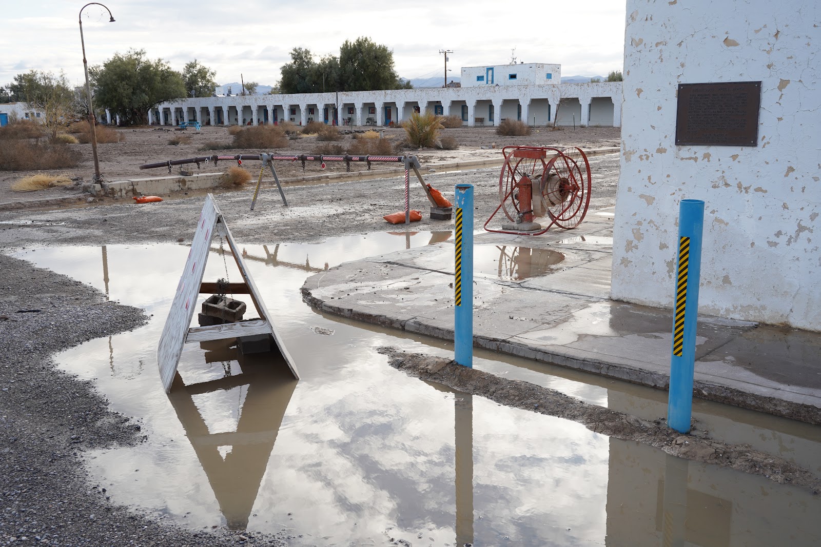
Amargosa Hotel after the deluge
From 1923 to 1925 the Pacific Coast Borax Company constructed buildings in the town, hiring architect Alexander Hamilton McCulloch to design a Spanish Colonial Revival whistle stop centered at the hotel, theater and office complex building, now known as the Amargosa Opera House and Hotel.

Amargosa opera house
The town already began to decline in the mid-20th century. In 1967 the car of dancer and actress Marta Becket broke down in this remote place. While the car was fixed she became enchanted by the abandoned theater. After finding sponsors to purchase the hotel and theater complex she played there until her last show in February 2012. Becket died in 2017.

Abandoned cafe and garage in Amargosa
The unusual downpours of the last days has turned the grand yard and the parking lot into a surface of mud and puddles. A part of the hotel next to the opera house is still operating. The remainder is abandoned. When we have a look a woman comes out and warns us not to enter with dirty shoes. The water and mud comes almost to the door step. The settlement’s revival died with Marta Becket. The town is in a state of disrepair. There is no gas station and the only restaurant, the Amargosa Cafe, is closed.
Tonopah
Begin of the 20th century the town of Tonopah just east of Death Valley became the booming center of a gold rush. Gold and silver mines started to pop up allover the area and led to the foundation of places like Beatty, Ryolite and Goldfield. In 1904, Francis Marion Smith, a California mining and railway tycoon, got the concession to build a railway connecting Tonopah, his own Borax mines in Lila C. and the next transcontinental railhead of the Atcheson, Topeka and Santa Fe Railway at Ludlow, California. The railway was called the Tonopah and Tidewater Railroad since the idea was to connect it to the harbor at San Diego. It never happened.

Fictional railroad crossing in Shoshone
The “Tired and Tardy” as the railway soon was to be nicknamed operated from 1907 until 1940. The Borax mines at Lila C. had closed in 1927. There still were other mining products like lead, feldspar or clay and general goods to be hauled. Together with the AT$SF and the Death Valley Railroad they started a common sleeper train for tourists from Los Angeles to Death Valley. However, the great depression and later the use of automobiles necked that attempt.

Along the former railway tracks of the T & T in Shoshone
Although the railway was finally closed down in 1940 most of the little towns along the line retain some kind of relic from its railway times. Shoshone, for example, boasts with a “railroad crossing” warning sign. A little shack and an outhouse in the former depot area could or could not have been part of the station.
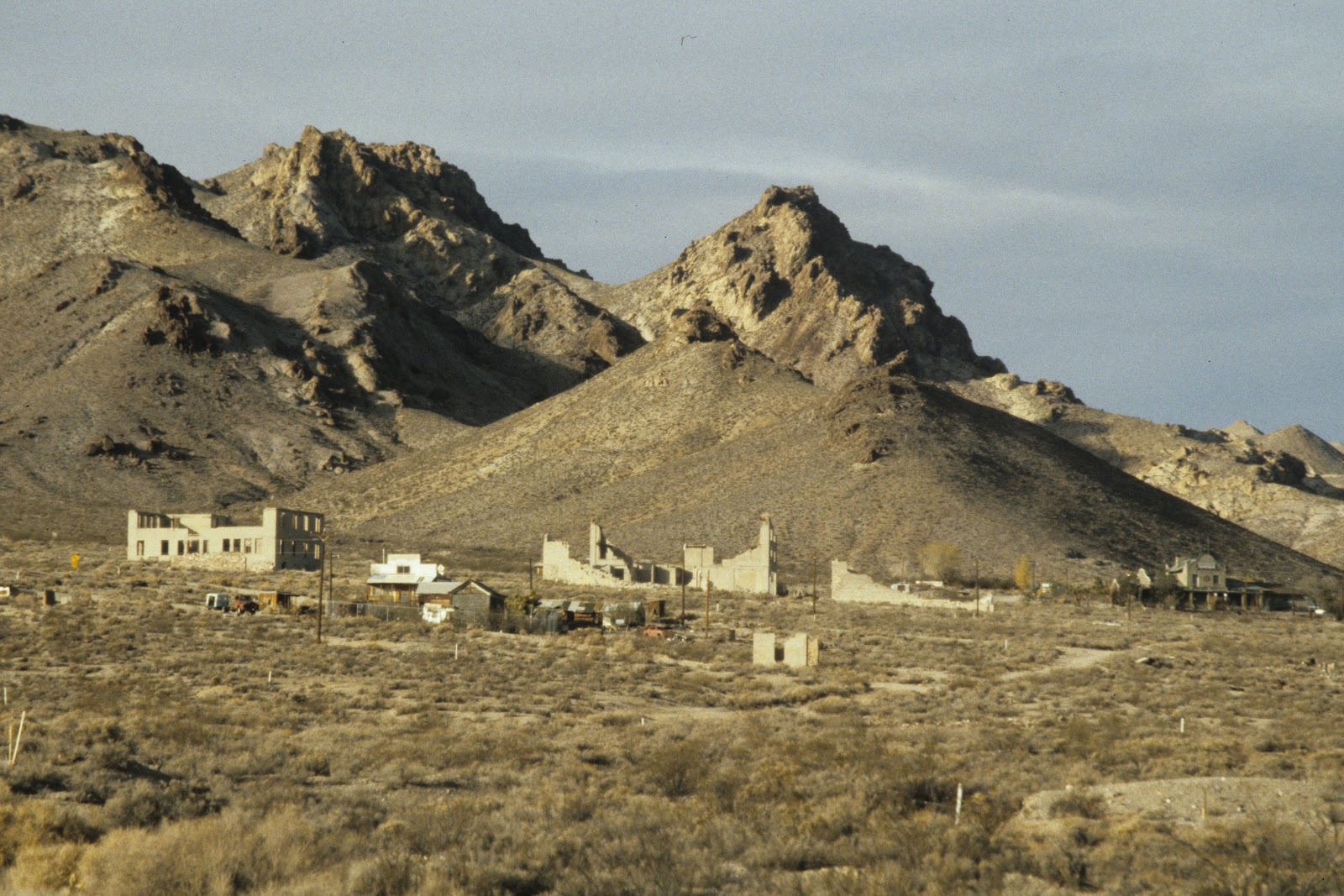
Ryolite
Once the T & T went past Ryolite. The Bullfrog mining district drew over 2000 claims in a 30 mile area, but the Montgomery Shoshone mine was the most promising. A boom town developed with buildings as big as 3 stories tall, a stock exchange, a red light district, hotels, stores, a school for 250 children, an ice plant, two electric plants, foundries and machine shops and even a miner’s union hospital.

Sunset at Ryolite
When electricity arrived in 1907 it allowed the mill consisting of a crusher, 3 giant rollers, over a dozen cyanide tanks and a reduction furnace to handle 300 tons of ore a day. Mr. Montgomery, the owner boasted he could take $10,000 a day in ore from the mine. However, already in 1907 a financial panic was the beginning of the end for the town. Mines started closing, banks failed, newspapers went out of business, and by 1910 only 611 residents were left. After the Montgomery Shoshone mine closed in 1911 the light and power were finally turned off in the town in 1916. The T & T already stopped their services north of Beatty in 1914.

Former 3 story bank building
Today ruins of some of the more solid buildings are still standing. There are the walls of the 3 story bank building, a part of the old jail and the bottle house, which was restored in 1925 by Paramount pictures. Most striking however, is the old train depot of the Tired and Tardy. It is more or less complete and privately owned.
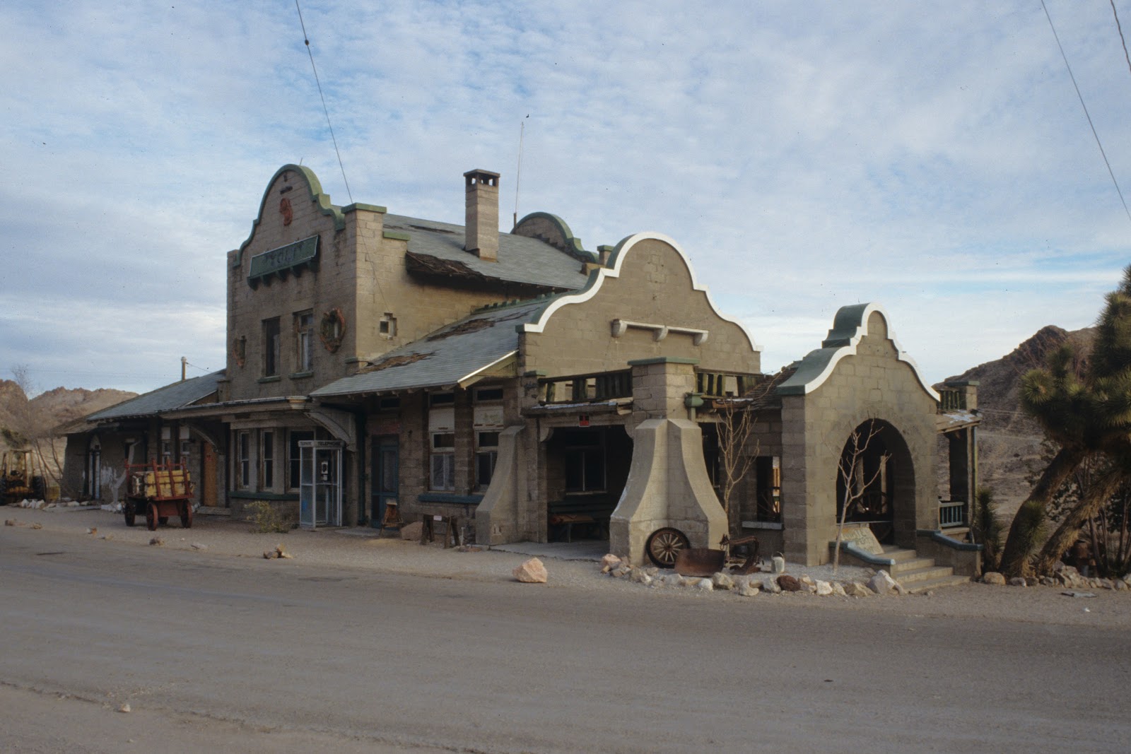
Ryolite station in 1988

In 1984 artist Albert Szukalski used the Ryolite site for his sculptures. White ghosts originally designed to last for 2 years dot the forgotten streets of the town. The white plaster of the "The Last Supper" contrasts starkly against the brown and gray tints of the desert.
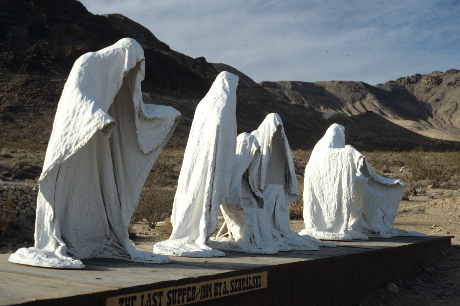
The Last Supper" by Albert Szukalski
Most famous travelers on the T & T’s remaining line were Chicago millionaire Albert Mussey Johnson, his wife Bessie and his friend Walter Scott, known as "Death Valley Scotty. Scotty had convinced Johnson to invest in his gold mine in Death Valley. Although the gold mine did not exist and the investment was fraudulent the two men became friends.

Scotty's castle
Since they discovered that the dry air of Death Valley was good for Johnson’s health he acquired 610 ha of land in Grapevine Canyon and started to build a ranch in 1922, later called Scotty’s castle. When the villa eventually became their winter home they traveled there from Chicago in their private rail car.

Ubehebe crater near Scotty's castle
For the time the ranch was quite advanced. The springs of Grapevine Canyon provided the water supply and operated a Pelton wheel to create the villa's electricity which was regulated and stored in nickel–iron batteries.

Steam tractor to pull waggon through the desert
When the stock market crashed in 1929 Johnson lost most of his fortune. On Scotty’s advice rooms in the castle were rented out. Eventually Scotty’s castle was bought by the National Park Service and incorporated as a curiosity equaling similar places like Hearst castle at the California coast or Biltmore in North Carolina. Unfortunately it is closed since 2015 when an unprecedented flood rushed down Grapvine canyon and buried the grounds under a layer of of mud.

Pathrump
For our next night we steer east across an entirely empty landscape towards the metropolis of Pathrump, Nevada. In the middle of a desert-like landscape a faceless metropolis has been carved out of the desert by irrigation. Neighborhoods seem to center around golf clubs. All public places are surrounded by huge parking lots. This is a place which not only is not catering for pedestrians or cyclists, but if you don’t move by car you are suspicious. There are no sidewalks or public transport of any usefulness. Crossing the wide thoroughfares is outright suicidal.

Casino hotel in Pathrump
Each state has its particular characteristics. Everybody knows that Nevada is the state of gambling. However, it also has different tax laws. There is no sales tax in Nevada. The main road is lined with casinos and fire-work outlets. When I go into a shop to buy a pair of trousers I end up in a corner inspecting fire-arms. The changing room is fitted with a numerical lock.

Highway in Pathrump
The Best Western Pahrump Oasis motel has an indian-chinese-american restaurant. The waitress is Czech. She arrived in the US six years ago. Why? She doesn’t appear to be very enthusiastic about the place she ended up. Her colleague is covered in tattoos. Under her transparent blouse she wears a red bra.

Restaurant in Pathrump, Nevada
The place advertises itself as brewery-distillery. The space with the barrels and tanks is deserted. In the diner there are big screens everywhere. People at the bar have individual screens and gambling spaces. Their attention is divided between their drink and the screen in front of them.

Homeless in Pathrump
Who lives in a town like this? The old, fragile woman with an even more fragile dog who assembles a couple of miserable groceries in the enormous shopping cart. On a bench next to the entrance a homeless man devours some meager leftovers in a plastic container. What he doesn’t swallow he drops on the floor which already is littered with refuse around him. It wouldn’t be far-fetched to suppose that he has spent his night on the same bench. There are several like him. The climate around here is favorable for homelessness and the huge portions offered in restaurants leave spill-overs to survive on.

Ice and water dispenser on the parking lot
The parking-lot has a dispenser where you can buy ice and water. The water-mill express. Where does the water for all the golf clubs, several showers per resident a day, pools and the watering of the public space and private gardens come from?
Civilized desert
In 1902 the Federal Bureau of Reclamation had big plans. A federally planed irrigation project was supposed to bring 75000 ha under cultivation in the Owens valley. Essence of the project was the construction of a reservoir in the Long valley, an area owned by Thomas Rickey, one of the biggest farmers of the area.

View of Owens lake from the base of the Sierra Nevada
At the same time the city of Los Angeles had passed a population of 100.000. Further development was limited due to lack of water. There were some artesian wells but the underground reservoir was depleting quickly. Los Angeles river, the only one in the basin, was seasonal. To ensure the growth of Los Angeles water had to be found and diverted in from outside.

Countryside outside Lone Pine
Fred Eaton, a Los Angeles politician and the City’s mayor, and Bill Mulholland, his successor as superintendent of the Los Angeles City Water Company, were convinced that they could find enough water: the Owens river would be sufficient as supply for a population of 1 million. The only problem was to bring it in over a distance of 400 km. Eaton and Mulholland, both engineers, were sure that the gradient from high lying Owens valley to sea level Los Angeles Basin was sufficient to bring the water in on its own power without any pumping.

Homestead in Lone Pine
The water in Owens valley was distributed to the farms with water rights via irrigation ditches. There were several ditch companies and the individual farmers had to pay for the maintenance of canals and ditches. There was little suspicion when individuals showed up in the valley buying land which had the best water rights. Additional participants in irrigation project meant reduced costs for the individual farmer and there was enough water for the valley. What nobody in the valley knew was that the representative of the Federal Bureau of Reclamation, Joseph Lippincott, played a double role: the water rights were not bought for the realization of the big irrigation project of the Federal Bureau of Reclamation but by the Los Angeles City Water Company. As soon as enough water rights were obtained the maintenance of the irrigation in the valley would become too expensive since the number of participants in the ditch companies would be too low.

Floor of Owens Valley
But even when it became known that an aqueduct to Los Angeles was to be built the valley residents were unsuspecting. Mulholland had created the opinion that the intake of the aqueduct would be downstream from the irrigation farms and only surplus water would be diverted to LA. However, in reality, LA and in particular some individuals, wanted all the water. While the project was ongoing they bought dirt cheap property in San Fernando valley, a fertile valley which was unpopulated at the time since there was no water. The aqueduct would pass through and the property there would immensely gain in value.

Floor of Owens Valley
There was still a minor problem. Officially the Federal Bureau of Reclamation was holding on to their plan for the irrigation of the Owens valley. In a shrewd plot Mulholland and some advisors of President Roosevelt convinced the president that the water would be much more important for a booming city of many hundred thousand or even a million residents than for a couple of valley farmers. The irrigation plan was abandoned and the right of way across federal land for the construction of the aqueduct approved.

Los Angeles aqueduct
It took seven years to built the aqueduct. Although the comparison some people drew with the building of the Panama canal or the great wall of China might be a bit exaggerated, the task was colossal. The aqueduct covered 358 km, of which 85 km were in tunnels. It also involved the building of siphons with acclivities of more than 50 degree grades, 200 km of railroad track, 800 km of roads and trails, 400 km of telephone lines and 270 km of power transmission cables. The amount of concrete was such that a separate concrete making plant had to be built. Since there was no fuel for steam power two electrical power plants had to built along the Owens river. The technology had been invented just on time.

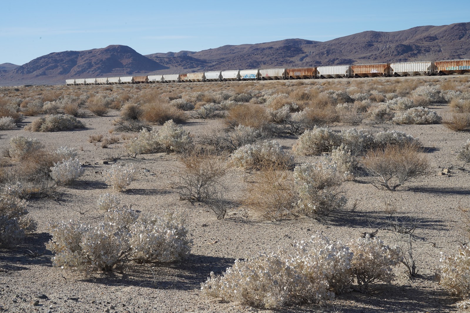
Owens lake
One of the railways built in 1912 to help with the construction of the Los Angeles Aqueduct was a 140 km long branch line which extended north from Mojave along Owens lake to Owenyo in Owens Valley where it connected to the narrow gauge line of the Carson & Colorado railroad between Keeler and Belleville.

Owens lake
After the building of the aqueduct Owens lake quickly dried up, leaving a salt lake. That offered new business possibilities for mining of minerals in the former lake bed and freight for the railroad originally built for the construction of the aqueduct. At Bartlett on the west shore of Owens lake the ruins of an abandoned industrial building still stands testimony for these mining activities.

Soda works of Pittsburgh Plate Glass Company in Bartlett
Since 1926 a soda ash plant stood at this site. The plant recovered sodium carbonate from the Owens Lake brine. In 1944, Columbia-Southern Chemical, a subsidiary of Pittsburgh Plate Glass Company, purchased the plant. Although the plant was upgraded in 1958 it was finally closed down in 1968. Interesting enough the closure of the plant was directly connect to … too much water. In the winter of 1967 to 1968 snowfall in the Sierra was exceptionally high. It was feared that the runoff from melting snow would flood the Los Angeles Aqueduct and the overflowing aqueduct would cause damage to towns and residents in Owens Valley. Therefore the aqueduct was temporarily breached and a great amount of water suddenly flooded Owens Lake to an extent not seen for 50 years. Extraction of brine for the Bartlett soda plant was not possible any more until the lake dried up again. The plant was closed. The closure caused another exodus from Lone Pine since the employees of the plant left to search their fortune elsewhere. The little company town of Bartlett completely disappeared.

Soda works
The deserted plant was bought by Dr. McCabe, a medical valve inventor. Together with some Hollywood friends he used it for recreation. Dr. McCabe died some years ago. His friends still own the building. There are some trailers on the grounds. I am burning with curiosity to learn what they were doing on these desolate grounds. Now there are plans to use it as a visitor center, museum or for renewable energy production.
Mineral extraction at Owens lake
The Bartlett operations were by far not the only ones along the lake shore. In the course of time the California Alkali Company operated here in 1917-1932, the Clark Chemical Company from 1927-1928, the Inyo Development Company from 1887-1920, the Inyo Chemical Company from 1917-1932, the Permanente Metals Corporation from 1947-1950, the Natural Soda Products Company from 1915-1952 and the Pacific Alkali Company / Columbia-Southern Chemical Corporation since 1928.

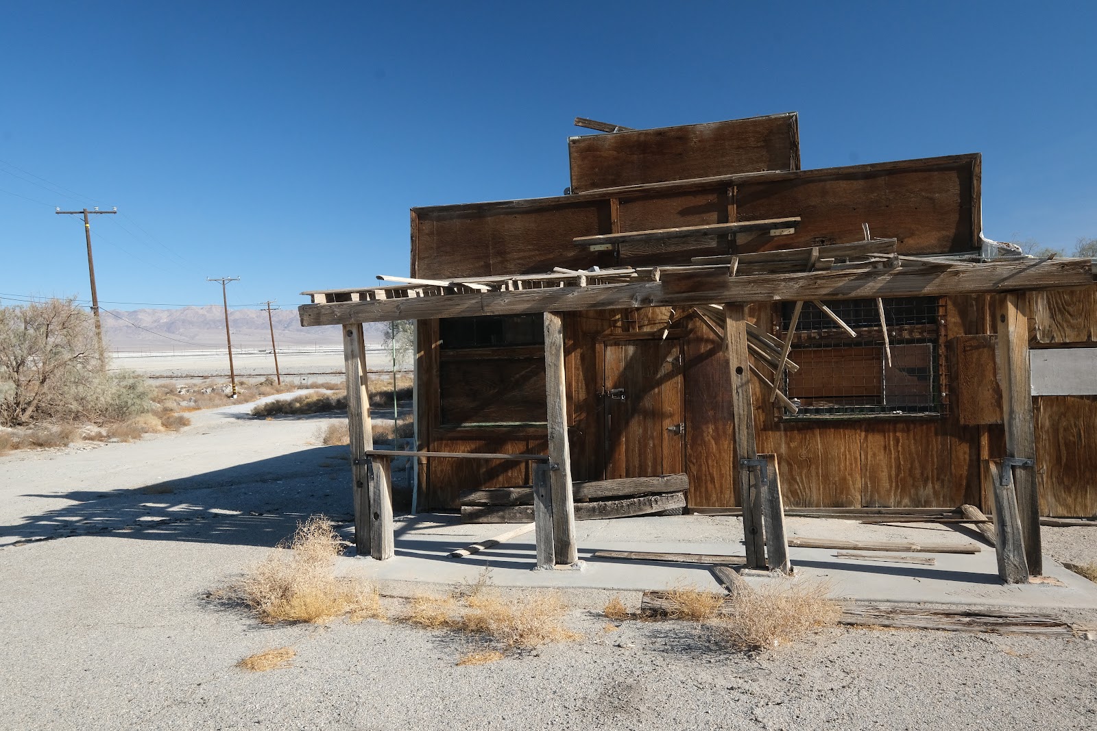
Former Olancha cafe
A bit further south was the train had a stop at Olancha. What I took as the ruin of a depot turns out to be an abandoned cafe. When we take pictures, a car stops. The driver seems to be concerned why we are hanging around here. The pub was closed five years ago and since then a lot has disappeared. He used to come here to see games. He tells us that eventually the cafe was taken over by some people who found it more important to smoke weed than to attend their guests.

Former Olancha cafe
The railway to Bartlett and Owenyo went out of service some time between 1972 and 1984. Although the track to Searles, a junction without town, was removed in 1999 the right of way and some small bridges are still visible.
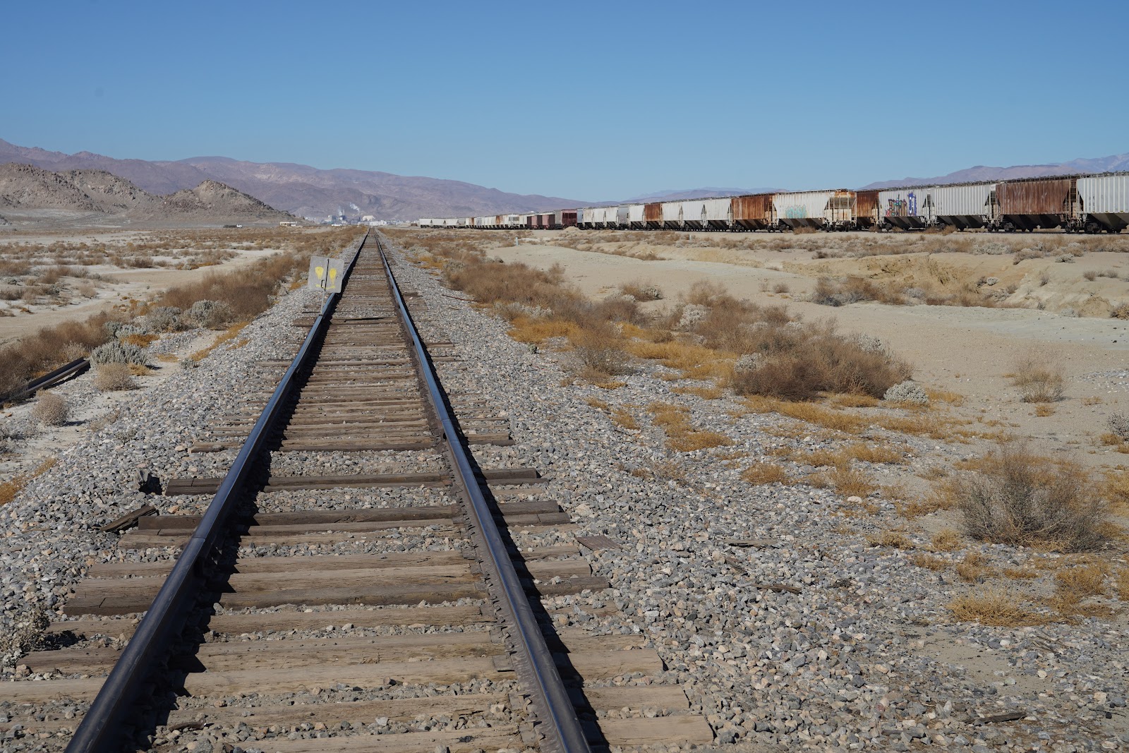
Trona Railway
At Searles, the Southern Pacific branch interchanged with the still-active Trona Railway. The line runs through desert to the town of Trona. Here Searles Valley Minerals produces borax, soda and salt. The company also owns the well-maintained railway line.

Searles Lake
Searles lake already was a mainly dried out salt bed in 1860, when John W. Searles arrived in the area prospecting for gold or silver. What he found was Borax, the white gold. In fact, the muck under the crust of the lake contains about half of all known natural chemical elements. Mule teams had the grateful task to haul the borax all the way to Los Angeles. After 1876, when the Southern Pacific had finished their route to Mojave the task of the mules became easier. After the operations were taken over by the American Trona Company in 1914 they also laid tracks to Searles. They also built a company town in Trona.

Searles Valley Minerals Inc.
When the plant was sold to American Potash and Chemical in 1974 they did not want the company town and sold it. The production was cut in half in 1982 and massive layoffs resulted. The company changed owners several time since then and is now a part of an Indian company based in Ahmedabad.

Searles Valley Minerals Inc.
Searles Valley Minerals Inc. is part of a partnership for the reduction of greenhouse gases. Nevertheless they operate the last coal fired power station still operating in California.

Trona
There also seems to be a problem with arsenic poisoning of workers at the plant. However, Searles Lake Minerals argues that the concentration of dissolved minerals in the brine of the natural pools of the lake is higher than in the discharge of the plant. Searles Lake brine houses a unique anaerobic bacterium which uses arsenic for respiration.

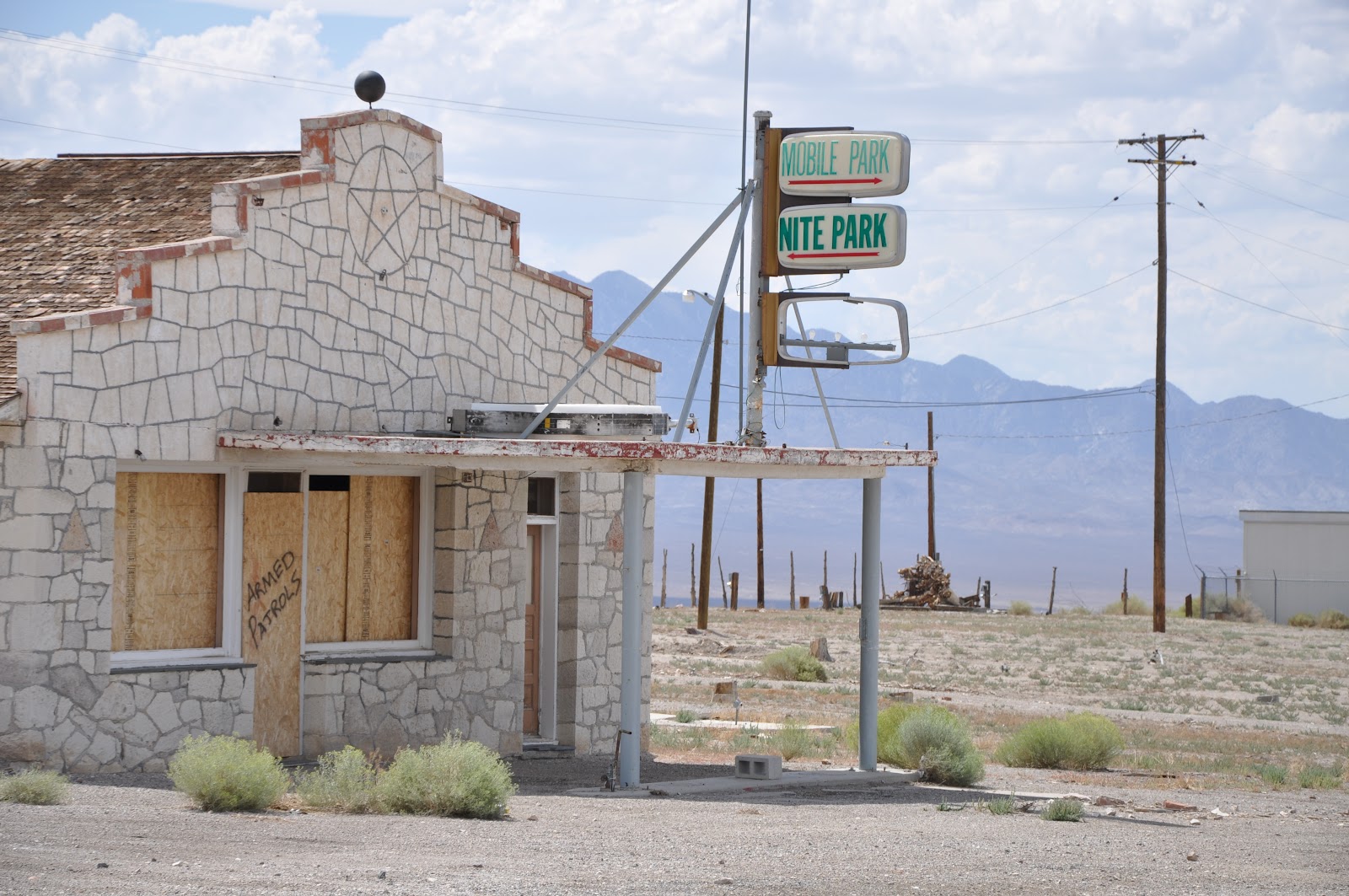
Abandoned gas station Trona
Migrating birds at the Trona plant brine ponds have died from salt toxicosis, salt encrustation, and oiling. In 2005, the company agreed on a plan of bird protection and rescue efforts and a half million contribution to create wetlands at the south end of neighboring Owens Lake. Since Searles Valley Minerals operates on government owned land they pay royalties of millions of dollars each year to both the federal and state governments. Much of those royalties cover the expenses of local school districts.

Trailer residence in Trona
The environmental questions might be the reason why two women from the plant’s security force approached us when we took pictures from the parking lot. They are not very intimidating. One has purple hair, the other is heavily overweight and even we could have outrun her. While they did not directly forbid us taking pictures they told us that we are not allowed on the parking lot since it is company property. Said so, the adjoining street would not be a problem to stay on. They became more friendly with each word, giving us touristic tips about interesting sites in the area.

Residence in Trona
The former company town is entirely run down. Everybody must become sick and miserable when living her. The flag proudly flies above abandoned gas stations, desolate trailers with yards decorated with worn out, dusty sofas, empty shop-buildings and the occasional home surrounded by wrecked and active cars. However, most of the residential buildings are boarded up.
Abandoned building in Trona
Trona is home to the very active Searles valley historical society and a mineral club. The historic society maintains five locations. One is in the old guest house, another the railroad museum in the former depot. Unfortunately all the museum buildings are open by appointment only. However, some of the exhibits like a caboose of the Trona railway can be enjoyed from outside the fence.

Trona railway museum
After the Trona railway started operations in 1914 it soon became known as the “three elephant route”. The reason was the mainly British staff, most of whom had served in India before. They were of the solid opinion that three elephants were easily able to do the work of Trona railway’s consolidation steam locomotives built by Baldwin. The railroad nevertheless was known for the immaculate condition of the engines which pulled freight trains and the daily pair of passenger trains in 90 minutes over the 50 km to Searles. Although passenger services stopped in 1937 the railway ran a special school train until 1941. For that reason they acquired a railcar which soon was known as the “skunk”. Whether this was the result of the car itself or its passengers is unknown to me.
Trona
While the Trona railway is one of the shortest railways in the US its future seems to be safe. The mineral deposits in Searles lake will last for centuries to come and are increasingly under demand. Earlier in the 20th century it was even served by two feeder lines, the narrow gauge Gravel Bank and Crystal Lake railway serving a mine in the mountains to the east, and the unique Epsom salt railway.

The latter was a monorail connecting to an Epsom salt deposit almost 50 km away in Panamint Valley. It was finished by 1924, but operated only until 1926. One million $ had been invested into the exploitation of the Epsom salt deposits but the problems with transportation, the bad quality of the mineral and legal problems caused the closure of the mine and the remarkable, innovative but unsuccessful monorail.

Stored cars of Trona railway
Unfortunately W. has lost his patience with my affection for desolate places and urges to leave Trona. Maybe he also is afraid that the lenience of the security staff has limits. So my exploration of the site is limited.
Searles valley
A short distance outside Trona a long line of hopper cars is waiting in the desert for their next use. A sign points to the Trona Pinnacles. When we reach the railway track the main road is closed. We follow a different dirt track purposefully disregarding a sign lying overturned in the dust. Since the track we take is leading towards one of the many military sites in the area it is better to know less.

Searles valley

The wrong route to the Trona Pinnacles
While we follow the dirt road we can see the tufa formations in the background. The roads gets worse. It eventually leads us to the formations but we don’t really feel like going back the same way. There are several distinct groups of these columns which stand in the desert like giant sentinels of a past civilization. A closer look discloses the interesting microstructure which holds together the extremely hard and sharp-edged pinnacles.

Pinnacles at Trona
While wandering around I meet two brothers, one from Seattle and one from Florida, who had the nice idea to meet here to spend a week together. Like ourselves they have the impression that they did not take the proper road to come here. There are several groups of pinnacles. The one, where we are, is separated by the next northerly one by a dry wash. There are several tracks crossing the wash to the group on the other side. Over there we also see signs and marker posts.

Trona pinnacles
Like the Alabama hills close to Lone Pine the Trona Pinnacles have been used by Hollywood. Best known movie filmed here was “Planet of the apes”, a movie that isn't made any better by a spectacular location.

Details of Trona Pinnacles
Getting to the northern part of the pinnacle formations is not easy. Most of the ascents to leave the sandy dry wash are too steep, too narrow or too bumpy for our voluminous, heavy vehicle. Staying in the sand of the wash implies the risk of getting stuck. We follow the tracks into the deep sand of the wash and don’t dare to stop. Full of envy we watch a guy with a high bottom Jeep on tires like balloons hobbling up the steep bank at another point.

Micro natural arch
Eventually W. steers the mastodon up a bank to the left. I get out to check whether there is enough ground clearance. Eventually we follow a track until we end up at the marker posts. On the other side they tell us that the area where we come from is off-limits for vehicles.

Trona pinnacles
Exiting the pinnacle area from the northern formation is easy. There is a clearly marked road. When we reach the long row of hopper cars we realize that the railway crossing is dug up and closed. There is a detour. It ends at the sign which we had seen before, lying in the dust. Now, a kind soul has set it upright again. It indicates the right way to go.

Searles Lake
The general opinion is that Los Angeles stole the water of the Owens Valley. However, there was nothing illegal about what the city did. The consequence was that the valley lost its water and the local farmers their basis of income while some people in Los Angeles became very rich. Irrigation in the San Fernando valley increased from 1200 ha to 30.000 in only 5 years after the completion of the aqueduct in 1913. By 1925 the population of Los Angeles had reached 1.25 million. Today it is 12.6 million.

Mono lake
In the beginning there was enough water for everybody, also for the Owens valley, since the first 2 decades of the 20th century were rather wet. After that, rain fall dropped and dry years came. Representatives of Mulholland bought even more water rights at high prices, investigating who of the valley farmers were in financial trouble or willing to move. But they also bought water rights from upstream areas as far as the headwaters of the Owens river at Yosemite National Park. It eventually threatened to dry out Mono Lake like Owens lake before that turned into a salt pan.

Mono lake reflecting the Sierra Nevada
Mono Lake and the eerie reflection of its tufa pinnacles in the water became famous all-over the world when it appeared on the cover of the 1975 album “wish you were here” of Pink Floyd. After the aqueduct and the dam at Crowley lake was finished the water level of Mono lake at the headwaters of the aqueduct steadily decreased. Tufa formations like those of the Trona pinnacles began to appear. At last the water level fell to such an extent that the island in the lake, an important sanctuary for breading birds, was threatened to become a peninsula. As such predators would get access to the breeding birds and destroy the nests and the chicks.

Tufa pinnacles at Mono lake
A water war began. The farmers of Owens valley tried to resist by force. First the sluice gates were opened and water was uselessly released across abandoned fields, later armed men dynamited stretches of the aqueduct. A gang opened the Gates in the Alabama Hills and after years, the Owens river flowed back in to the lake for the first time. Los Angeles sent a special train with detectives who organized road blocks to get the situation under control.

Aqueduct
To balance the water flow the long planned reservoir in Long valley was finally built. Since that time Crowley lake forms a buffer to regulate the water flow. By the 1930’ies Los Angeles owned 95 % of the farm land in the valley and 85 % of the property in the towns. There was so little water that even desert vegetation struggled to survive. Alkaline dust was blown from the dried out Owens lake into the surrounding valley, threatening the remaining residents.
Owens lake
In the 1980’ies the attitude regarding water consumption and environmental issues changed. At first law suits forced Los Angeles to reduce diversions and give some water back to Mono Lake. The water level of the lake, which had decreased for 40 years, started to stabilize. The tufa formations actually got wet feet again. Some years later, the city actually returned some water to the Owens River. For the first time it could be called a river again. Parts of Owens lake are kept wet to decrease the formation of alkaline dust. Mulholland’s department of Water and Power in Los Angeles was all but taken over by environmentalists. Suddenly it is regarded as more important to keep water in a lake to preserve migrating birds than use it for growing alfalfa to feed future steaks.

Father Crowley Vista point, Death Valley
Link to previous post:

Sunset, Death Valley
Sources:
Marc Reisner, Cadillac desert, edition with postscript 2017
David F. Myrick, Railroads of Nevada and Eastern California, University of Nevada Press, 1992, Volume I and II

Death Valley road at night